How one obscure Bristol back-alley runs through two thousand years of history: from Romano-British settlements, to Grey Friars, pauper’s burial grounds, cutpurses and wasted Walnut trees.
For a long time it didn’t have a name. It was just the lane that ran along the back of Mum and Dad’s bookshop. You couldn’t even see it from the small square yard outside the Wise Owl’s rear basement door. To access the door and the heavy bolts that secured it, you had to negotiate the stacks at the bottom of the dark stairs, squeezing past boxes of old foxed hardbacks, lost LPs, musty sheet music and cobwebs abandoned to the dust.
Out back was a tiny space with a whitewashed wall and what I think was an old toilet block. On the other side of the wall was land that had once been part of the Bristol Royal Infirmary’s Cemetery. Although back then – this would have been the late 70s and early 80s – all us kids knew was that the place on the other side used to be a graveyard.
Sometimes I’d dare a peek over the top of the wall, but all that could be seen from there was an area thick with buddleia and other wild flowerings. My imagination was quick to populate the space further with various other unnamed horrors, so I’d never hang around. After a nervous glimpse, I’d scramble back down to the ground and in through the door before sliding the bolts back across in delicious relief.


By the time I had reached my teens I knew that the old alley out back had a name: Johnny Ball Lane. For ‘A’ level English, I think, a group of us shot part of a film version of T.S. Eliot’s Preludes down there. What I liked about the place by this time was that if you didn’t know that it was there, and no one showed you, you’d be unlikely to stumble across it. This meant that knowledge of its existence lent you a small degree of topographical kudos. Not that I would have termed it anything as pretentious sounding when I was 16.
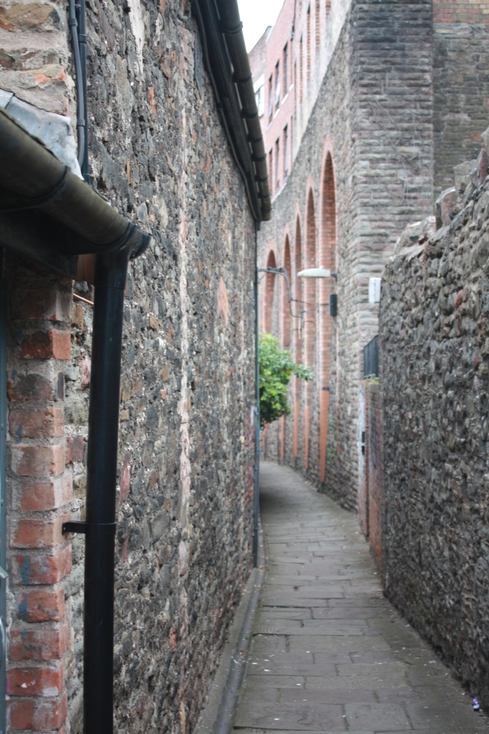
At one end, the lane is accessed from Upper Maudlin Street opposite the main entrance to the BRI. A narrow pathway drops abruptly down a flight of stone steps. From here the passage looks almost like a dead-end, but a sudden right turn leads into the main route of the path.
In the next stretch just beyond where the back of the shop was, massive grey stone and red brick vaulted walls loom high overhead on the Upper Maudlin Street side of the lane.

Nowadays these make me think of Gustave Doré’s illustrations of slums in Victorian London. Then, the huge walls more readily brought to mind the vast bulk of some Gormenghast-like castle – that or the thick ramparts of Bristol’s Horfield Prison.
Either way, these towering canyons of brick and stone can make those walking the route feel very small. The great walls also block out considerable daylight, so Johnny Ball Lane can be pretty gloomy much of the time: an impression unrelieved by the dark flagstones underfoot or the dull glow of the streetlights.

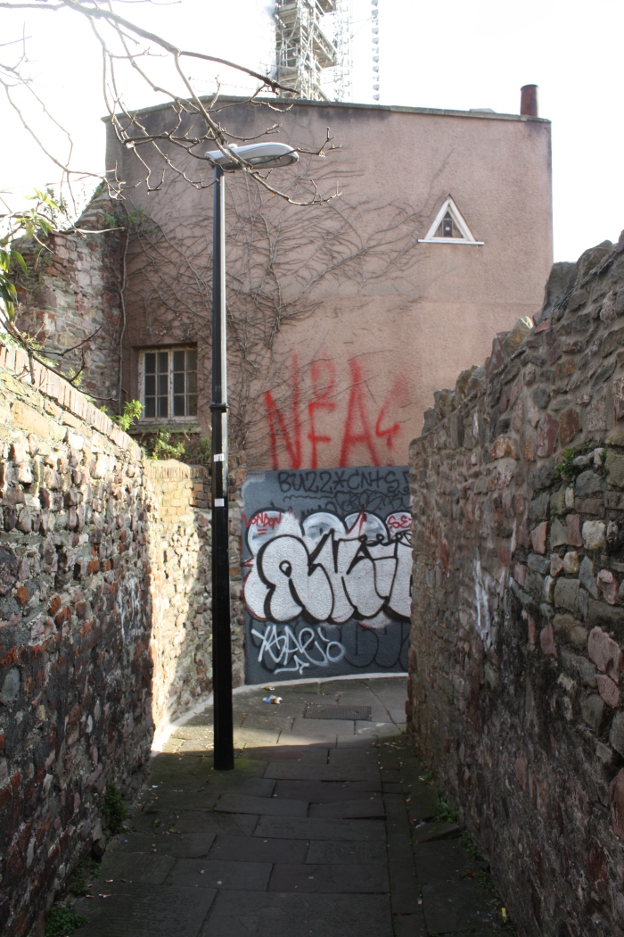
From here the lane runs on in a gentle downward slope, before meeting another few steps, then another sharp corner and more steps, where it finally emerges onto Narrow Lewins Mead in between two undistinguished looking office blocks.
At this point if you head left you’ll hit the shops of Broadmead, turn right and you’ll reach the bottom of a far more famous Bristol thoroughfare – Christmas Steps, where you can still find a decent fish and chip shop based in a building that was once part of the medieval Bartholomew’s Hospital.

 Almost immediately in front of this end of Johnny Ball Lane is a striking bronze rider on horseback. The figure, (possibly a medieval friar), is staring across the road in the direction of St John’s Gate – the only survivor of the seven medieval gateways to the old city.
This haunting statue is called simply ‘Cloaked Horseman’ and was made by the sculptor David Blackhouse. Somewhere beneath the horse’s feet runs the river Frome, which was culverted at around this spot in the 1890s.
From time to time the rider acquires a somewhat louche look, as he contemplates the vanished city before him, whenever some passing wag sticks a cigarette in his sculpted mouth, transforming him into an early medieval Marlboro man.


Look up Johnny Ball Lane online today and you are likely find some photos of contemporary graffiti on some of its walls, along with some jokey speculation that it is named after Zoe’s Ball’s dad – the much-loved former presenter of Think of a Number and other classic kids TV of the 80s.
Although that Johnny Ball was actually born in Kingswood, Bristol, before his parents moved to Lancashire, the lane isn’t named for him. A glance at Veronica Smith’s ever useful Street Names of Bristol informs us that the lane was once known as Bartholomew’s Lane, but that it’s present name ‘would seem to be a corruption of the name of John a Ball who owned the property adjoining the Franciscan Friary that stood in Lewins Mead. Some also suggest that he had some responsibility for the erection of Bristol Bridge.’


It is clear that this is a lane with history; only a little research indicates just how rich and deep a history that is.
One unexpected source, the website for the University of Bristol’s School of Oral and Dental Sciences, has an extraordinary amount of detail concerning the area where the teaching buildings exist today. This site reveals that the present Dental and Eye hospital is built on land that was once within the precinct of Bristol’s Greyfriars Priory, which according to local chronicler William Worcestre, or Wycestre, writing in around 1480, was bounded by Lower Maudlin Street on the East, Upper Maudlin Street on the north, Lewins Mead to the south and Johnny Ball Lane to the west.
Worcestre was a kind of early travel writer, who spent much time pacing out measurements of buildings and places he visited as well as talking to locals – notably Brandon Hill’s Hermit, whose cell he also sized up (Worcestre’s measurements make for an interesting rough guide, but not necessarily accurate in modern terms: comparisons of various of his notes made on different trips to Bristol can be subject to wide variation).
He was born in Bristol in 1415, but spent long periods of his life elsewhere working for Sir John Fastolf as his land agent, during which he kept diaries and extensive notes. These observations according to the Bristol Record Society’s Vol 51 – William Worcestere: The Topography of Medieval Bristol, were often written “in lively and most un-classical Latin, occasionally lapsing into English.”
When he retired in 1480, Worcestre paid a return visit to his home town, which he then assiduously paced around, walking the streets, surveying, measuring and counting the lengths of various important buildings and byways. I can’t find an explicit reference to either Johnny Ball or the earlier Bartholomew’s Lane, but I’m pretty certain that this is what Worcestre is referring to in the following passage:
“The road going up I the steep hill of St James’s priory past the jousting- place of olden days. The road in the parish of St James, on the west side of St James’ church , next to the main entrance gate into St James’s priory, and the east side of the wall of the Franciscan Friars.
A long road or lane from the end of the Lewinsmead road opposite St James’s churchyard , going past the gate of the prior of the monks of the said church, and thus continuing to the further end of the said road or lane, past the walls of the gardens of the Franciscan Friars, to a certain steep hill on the northern side of the said far end of the road ; and turning along another road that turns off, leading towards the hill of St Michael’ s church. The said road or lane upwards measures 300 steps. And the turning off from the said road at the east end, past the wall of the said Friars Minor, as far as the lane going to St Michael’ s church ,and thus continuing due eastwards as far as a tall stone cross , set up in freestone, with a well walled with freestone , at the upper end of the road coming from the church of St Bartholomew’s hospital, called Steep Street, measures 600 steps.”
I love the idea of the retired William Worcestre winding his way along an early version of Johnny Ball Lane, passing the gardens of the Grey Friars and cheerfully scribbling down notes about the area as he went: a kind of Gandalf figure returning to Hobbiton to check on his beloved halflings.


It is clear that this atmospheric back alley has been a public footway for a very long time. Even further back in time than Worcestre’s excursion along it – the land nearby was the site of Bristol’s earliest known Romano British settlement.
Thanks to a fairly constant stream of developments by the city authorities, Bristol University, hospital trusts and private corporations, archaeologists have been kept busy in the last few decades, assessing the underground history of the area.
As a result it is possible to find several records of excavations from recent decades, including one in the early 1970s that uncovered evidence of a small late 2nd century Roman Settlement, which seems to have been in continual occupation until around the 5th century.
Later digs and desk based assessments reveal further nuggets, such as the existence of a house and garden in the 1670s and a later tenement known as the Soldier’s Infirmary. I was intrigued to discover that the burial ground, which had once been sited behind Mum and Dad’s shop, was not simply an old church burial ground, but had been used especially for the Bristol Royal Infirmary. For a century between 1757 and 1857 the ground was used for the burial of paupers who had died in the Infirmary. After this time, most of the bodies were removed and reburied elsewhere.


However, in 2004, according to the Transactions of the Bristol and Gloucestershire Archaeological Society: “A wide strip along the centre of the former burial ground was cleared down to bedrock; most of the burials were removed during excavations in 2002, but along the edges a small number of burials was exposed. These were recorded and removed. The remains of a house pulled down in 1747 to make way for the burial ground were also identified.”
I was also interested to find a reference to Johnny Ball Lane as the haunt of 18th century muggers in G. Munro Smith’s A History of the Bristol Royal Infirmary:
“Swords were not merely for ornament in those days. A surgeon visiting the Infirmary after dark might find the weapon useful. For instance, in 1743 ” a gentleman walking in Johnny Ball’s Lane ” (adjoining the House) ” was attacked by a Fellow dress’d in blue, with a blue apron on, a little Hat uncock’d, of a middling stature,” who proceeded to rob him. The visiting Staff were expected to live in Bristol, not in the neighbouring villages of Clifton or Redland, otherwise they would have run the risk, on night visits, of being stopped by highwaymen.”
Some things, it would seem, change rather less than others over time.
So from Roman Bristolians, medieval Fransicians and ancient chroniclers, to Georgian muggers and modern day taggers and street artists, this little narrow lane has a rather rich and multi-layered history. This is apparent even from a fairly cursory search. Yet, books and the internet can only take you so far, the best story I uncovered came direct from my Dad.
On a recent visit to my parents, I mentioned that I was thinking of writing something about Johnny Ball Lane, and asked if they had any personal recollections to share. To my delight, Dad did, a rather bitter-sweet memory from the early 1970s.
At that time, a considerably smaller and younger me used to take naps upstairs in the shop. I have some vague and dim memories of staring up at a poster of the evolution of Man – Darwin’s classic ape to hominid progression, but no other recollections of this period, so I’ll finish with my Dad’s words on what once happened in the patch of ground out in the back:
“Johnny Ball Lane leads off Upper Maudlin Street and turns behind the row of shops that include No. 26 – which was The Wise Owl Bookshop. There, in the 1970s, I could look out from the first floor rear window upon the enchanting, walled garden that lay behind the shop. In the centre was a tall and unusually straight walnut tree, the playground of squirrels and roost of pigeons.
A small green space with a dark underlay, for the garden had been, in the 19th century, the burial ground for unclaimed bodies from the Bristol Royal Infirmary. By the 1970s, however, the garden itself was used as a private retreat for the benefit of the lady who ran a small café at the top of Johnny Ball Lane. The café, but not the garden, provided a happy eating and meeting place for our more enthusiastic regular customers.
But such idylls seem doomed, as this one was, by the blight of ‘developers’. We had managed to obtain a preservation order on the tree, but being part of an overall plan for the area this order was overturned and the tree was felled. And then, adding folly to wickedness, it was burned – despite the value of walnut as timber.
Unable to halt ‘progress’ we did manage to delay it, by suggesting to the labourers sent to clear the ground that it had been a plague pit. Only after mechanical diggers had cleared the site – the bones being buried elsewhere – was the garden finally turned over to dereliction, in which state it stagnated for many years.
Johnny Ball Lane remained untouched by all this, but its nature changed for the worse when the few dim street lamps – almost the last gas street lamps in Bristol – gave way to electricity and yellow sodium.” – Robert Gilbert
 1903 Map of the Johnny Ball Lane Area (entrances/exits either end marked in red). Reproduced with the permission of the National Library of Scotland under a Creative Commons Licence. http://maps.nls.uk/index.html
Links and References
Arrowsmiths Dictionary of Bristol, J. W. Arrowsmith, Bristol,1906
A History of the Bristol Royal Infirmary by G. Munro Smith. Bristol: Arrowsmith, 1917
Bristol Record Society’s Publication Vol 51
William Worcestre: The Topography of Medieval Bristol, 2000.
General Editor, Joseph Bettey, M.A. P.H. D. F.S.A. Assistant Editor, Elizabeth Ralph M.A. D. Litt. F.S.A
Archaeology/History
University of Bristol School of Oral and Dental Sciences http://www.bristol.ac.uk/dental/about/history.html
Bristol in the Roman Period
https://www.bristol.gov.uk/documents/20182/33848/Bristol+in+the+Roman+Period.pdf/a43f09be-d4f9-4544-84b9-a03730305c92
http://www.bristol.ac.uk/Depts/History/bristolrecordsociety/publications/brs51.pdf
Transactions of the Bristol and Gloucestershire Archaeological Society
http://www.bgas.org.uk/tbgas_bg/v124/bg124213.pdf
https://csweb.bournemouth.ac.uk/aip/online/B/south%20west/BBRISTOL.pdf
Bristol Greyfriars
http://www.pastscape.org.uk/hob.aspx?hob_id=1007750
Other
Bristol Evening Post
http://www.bristolpost.co.uk/news/bristol-news/how-12-bristols-most-bizarre-11788
Cloaked Horseman Statue
http://www.pmsa.org.uk/pmsa-database/12277/
Johnny Ball Lane National Library of Scotland Map
http://maps.nls.uk/geo/explore/#zoom=18&lat=51.4572&lon=-2.5972&layers=168&b=1
2012 photo comp – display in Johnny Ball Lane
http://www.iainsinclair.org.uk/2012/03/29/calling-for-artists-to-show-their-


Brilliant! Brought back memories. My Mum and Dad owned a Gents Hairdressers in Colston Avenue. As a kid from 1946 onwards I used the area round Christmas Steps to reach St Michael’s C of E Primary School (I was the only Rovers Supporter in the school) and Cotham GS and also to get to Alfred Sports Table Tennis Club, behind the Chapel in Lewins Mead. Even in those days there was a great Chip Shop at the bottom of Christmas Steps.
LikeLiked by 1 person
Fascinating history as I wait for my son to finish at the Eye Hospital so thought I’d take a walk down the lane and look up its history.
LikeLiked by 1 person
Who would have thought that this little alleyway could have had the rich history you have unearthed. It’s part of Bristol’s rich heritage and Thank you for your diligence in bringing it up for us to see.
LikeLiked by 1 person
Excellent – really enjoyed the mix of memory, images and history. What a great hidden place to know from childhood.
LikeLiked by 1 person
Thanks. I’d been meaning to write something on this since I first started the blog. Hadn’t realised quite how historic it was before. Nor that Mr Worcestre would be involved.
LikeLike
Who knew that so much could be said about one little lane? I have a feeling it plays a supporting role in my first (Super-8) film Heart of Darkness as well. My friend Mike (now an insurance investigator in Melbourne) wandered around different parts of Bristol, looking depressed, which was a reasonable response to most of Bristol back in the early 80s, and at one point I think he finds himself in Johnny Ball Lane, with David Bowie playing in his head. Or it could have been Nik Turner of Hawkwind. Playing the music in Mike’s head, that is. Although Nik Turner probably has found hjmself in Johnny Ball Lane at some point.
LikeLiked by 1 person
Fascinating article. Do the “Maudlin” references indicate a leper hospital?
LikeLiked by 1 person
There was a church of St Mary Magdelene nearby, think the name derives from that. Will look into the leper connection.
LikeLike
I am no expert but I was under the impression that streets named Maudlin often referred to the site of a leper hospital. I happen to live on Maudlin Road in Totnes and there was definitely one near here, I believe the same connection exists in Exeter.
LikeLike
No, it refers to Magdalen, as in Maudlin (Magdalen) College Oxford
LikeLiked by 2 people